
Urban congestion has become a structural challenge, costing the global economy over $400 billion annually in lost productivity, fuel waste, and health impacts. Despite rising investment in transit, drivers in major cities still lose up to 130 hours per year in traffic (INRIX, 2024).
Smart traffic systems offer a data-driven solution combining AI signals, sensors, real-time analytics, and computer vision to cut congestion by up to 30%. No longer experimental, these systems are being deployed at scale, reshaping urban mobility with adaptive, decentralized infrastructure.
Urban Congestion Needs Smarter Systems
Legacy traffic systems were designed for cities of the 1980s: predictable, low-density, and largely vehicle-centric. They were not built for today’s hyper-connected, dynamic urban environments.
Why traditional systems fail:
- Fixed-timing traffic signals, often calibrated years ago, don’t respond to live conditions.
- Siloed data systems prevent holistic understanding across intersections and zones.
- Manual monitoring of traffic across hundreds of intersections is inherently reactive.
- No predictive capability, meaning bottlenecks form before any response occurs.
As urban mobility patterns grow more complex with delivery fleets, ride-sharing, micromobility, and special events static infrastructure leads to cascade failures, where one small disruption ripples across the entire network. In many metro areas, peak congestion now extends over 5+ hours daily, effectively removing “off-peak” flexibility. Traditional infrastructure cannot adapt to this fluid demand. Smart traffic systems represent more than an upgrade, they are a paradigm shift from static control to real-time, AI-driven coordination.
Core Technologies Driving Smart Traffic Systems
Smart traffic systems are not defined by a single device or algorithm. Rather, they are orchestrated ecosystems that combine multiple technologies to form a real-time, adaptive, and learning-based traffic control infrastructure. Together, these systems allow cities to respond to live conditions, predict emerging congestion, and coordinate across entire networks not just isolated intersections. Four foundational technologies drive this transformation.
1. AI Traffic Signals: From Fixed Timers to Dynamic Intelligence
Traditional traffic lights operate on fixed schedules, unable to account for real-time flow, directional surges, or unexpected events. AI traffic signals replace this rigidity with responsive intelligence. These systems analyze live data streams such as vehicle counts, queue lengths, and historical patterns to optimize signal timing at every intersection. Instead of operating each junction in isolation, AI controllers coordinate traffic across a corridor or zone, balancing throughput and minimizing idling.
This shift reflects a broader movement toward more intentional AI implementation. As discussed in this analysis from Twendee Labs, embedding AI effectively means solving real-world problems not just adding layers of complexity. Traffic systems provide a clear, measurable case where AI delivers tangible impact.
Unlike static systems, AI-powered traffic lights adapt dynamically to current traffic conditions. Using data from vehicle speed, direction, lane density, and signal state, these systems minimize waiting times and optimize green light allocation.
The diagram below illustrates how a reinforcement learning agent evaluates traffic flow in real time — adjusting signal phases based on lane density, red-light duration, and cumulative waiting time to reduce congestion system-wide.
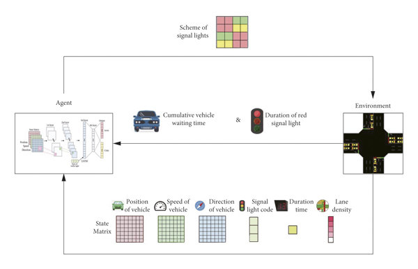
AI traffic light system using reinforcement learning model (Source: ResearchGate / IEEE)
A prime example is Pittsburgh’s Surtrac system, developed by Carnegie Mellon University. By using decentralized AI agents at intersections, Surtrac has reduced average travel time by 26% and vehicle emissions by 21%, while continuously learning from evolving traffic conditions (CMU Robotics Institute, 2023). These systems are also equipped to detect emergency vehicles, enabling green corridors during critical response times, and can dynamically adjust priorities for mass transit or freight routes based on demand.
2. Sensor Networks: The Nervous System of Smart Mobility
At the heart of any smart traffic system lies an expansive sensor network that captures real-time data from the physical environment. Cities deploy a mix of inductive loop sensors embedded in roads, radar and LIDAR detectors mounted at intersections, and acoustic or vibration sensors for additional precision. These devices measure a wide range of variables:
- Vehicle speed and volume
- Lane occupancy and turning patterns
- Environmental conditions such as fog, rainfall, or surface temperature
In Seoul, one of the most sensor-dense cities globally, more than 1.2 million IoT devices continuously transmit data to the transport control center. This enables rapid response to incidents and allows the city to prioritize public buses during peak hours. These inputs are not just observational, they are predictive. Sensor data feeds directly into AI models that can forecast congestion buildup, detect anomalies, or flag near-miss events for further investigation.
3. Computer Vision: Seeing and Understanding Traffic in Real Time
While traditional traffic cameras passively record footage, modern AI-enhanced vision systems actively interpret what they see. Using computer vision and deep learning models, smart cameras can identify not just the presence of vehicles, but their type, size, behavior, and compliance with traffic rules. They can also track pedestrians and cyclists, an essential feature for modern cities focused on multimodal mobility and safety. According to Frost & Sullivan (2025), over 60% of new intersections in Tier-1 smart cities now deploy AI vision systems for dynamic queue estimation, red-light violation detection, and proactive congestion monitoring.
These visual systems also support edge analytics, where data is processed locally at the camera level enabling ultra-low latency responses, such as adjusting signal cycles within seconds after a traffic surge or an obstruction is detected.
4. Real-Time Flow Control Platforms: Orchestrating the Entire Network
Sensors and AI signals provide the inputs and local decisions—but at the city level, real-time flow control platforms act as the command center. These platforms ingest millions of data points per minute from all subsystems and synthesize them into actionable directives. Built on cloud-native or edge-accelerated architectures, they serve three core functions:
- Predictive modeling: Simulating upcoming traffic conditions using historical and real-time data
- Multi-junction coordination: Aligning signal timings across districts or arterial roads to minimize stop-start dynamics
- Public interface integration: Providing live routing recommendations to navigation apps, electronic signage, and transit operators
In Singapore, the JTC Smart Traffic Management Platform is a benchmark for this model. By fusing sensor, signal, and weather data, and running AI models at the edge, it has reduced bus delays by 18% across key industrial and commuter corridors. These platforms don’t just react, they anticipate. They create a holistic traffic control layer that replaces fragmented, slow-moving systems with intelligent, city-wide synchronization.
Why Smart Traffic Systems Are Economically Scalable
Beyond their immediate impact on mobility and public safety, smart traffic systems deliver broad economic value both at the city level and across national economies. They not only improve traffic flow but also reduce energy consumption, support environmental targets, and enhance urban productivity. Critically, advances in cloud computing, AI-as-a-service, and modular IoT architectures are making these systems financially accessible and scalable, even for mid-sized or resource-constrained cities.
1. Multi-Dimensional Economic Returns
Smart traffic systems reduce costs and unlock economic gains across several key dimensions:
- Fuel and Maintenance Savings: Smoother traffic flow translates to fewer stop-and-go cycles, reducing fuel consumption and wear on engines, brakes, and tires. For logistics companies and public transit operators, this equates to significant operational savings.
- Time Recovery and Productivity: Time lost in traffic is not just inconvenient, it has a calculable economic cost. Commuters, delivery drivers, and service personnel all lose efficiency during delays.
- Health and Environmental Impact: Vehicle idling and traffic congestion are leading sources of urban air pollution. Reduced emissions help lower rates of asthma, cardiovascular illness, and related healthcare burdens.
- Emergency Response and Public Safety: Optimized signal coordination reduces emergency vehicle response times, which can save lives and reduce the downstream economic cost of delayed medical or firefighting intervention.
2. Scalability Through Modern Tech Stack
Historically, large-scale traffic systems required massive capital investments in hardware, fiber optics, and custom software. Today’s systems, however, benefit from three architectural breakthroughs that dramatically reduce cost and complexity:
- Cloud-Native Platforms: Many smart traffic systems now run on cloud infrastructure or hybrid cloud-edge models, reducing the need for local data centers and enabling instant scaling across districts or cities. Updates, training models, and analytics can be pushed over-the-air.
- Modular, Vendor-Agnostic Design: With open APIs and standards-compliant protocols (e.g., NTCIP, MQTT), cities can integrate hardware from different vendors cameras, sensors, controllers without locking into a single proprietary ecosystem. This lowers upfront procurement risk and encourages long-term flexibility.
- AI-as-a-Service & Model Portability: AI traffic optimization engines can now be trained on anonymized traffic data from one city and fine-tuned for another, drastically reducing the time and cost of deployment. This enables smaller municipalities to benefit from models developed in larger urban centers.
3. Democratizing Access for All City Sizes
Perhaps most importantly, the scalability of modern smart traffic systems is not limited to mega-cities. With modular sensor packages, edge compute devices, and subscription-based software models, even municipalities with modest budgets can:
- Start with a small number of intersections or corridors
- Use mobile-based data collection before investing in fixed sensors
- Scale horizontally as budgets, grants, or local needs evolve
In short, smart traffic systems make both economic and operational sense. They create immediate value in the form of lower costs, cleaner air, and better service delivery, while also laying the groundwork for broader smart city initiatives from connected transit to real-time logistics. Thanks to the scalability of today’s technology stack, these benefits are no longer reserved for global capitals, they’re available to any city with the ambition to move smarter.
What Comes Next: A Decentralized Layer for Urban Mobility?
While today’s smart traffic systems are delivering measurable value through centralized infrastructure, a new movement is emerging that could redefine how cities build, operate, and govern that infrastructure altogether. This movement is called DePIN – Decentralized Physical Infrastructure Networks.
At its core, DePIN introduces the idea that public infrastructure doesn’t need to be owned and operated solely by governments or large corporations. Instead, physical assets like traffic sensors, road-edge compute units, or even camera nodes can be distributed, community-operated, and connected via incentivized blockchain networks.
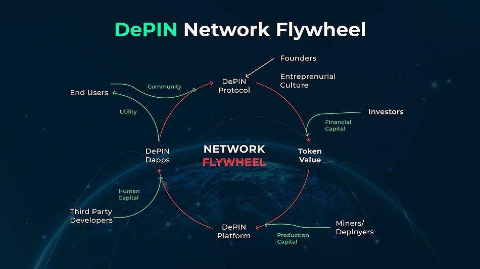
DePIN network flywheel showing user-token-platform loop (Source: Messari)
In the context of urban mobility, DePIN opens up a new model where:
- Traffic data can be sourced from independently owned devices, reducing the capital burden on cities
- Real-time sensor coverage becomes more resilient and dynamic, as contributors are rewarded for uptime, accuracy, and location value
- Governance over infrastructure protocols, upgrades, and data policies is shared across stakeholders rather than centralized agencies
Emerging projects like DIMO and MapMetrics already allow drivers and contributors to share GPS or traffic data in exchange for tokens creating an open, crowdsourced telemetry layer without compromising privacy.
The implications for traffic systems are significant. Cities could tap into shared networks of edge infrastructure, avoiding vendor lock-in and reducing costs. More importantly, decentralized validation could strengthen public trust in how traffic data is used, audited, and improved over time.
This doesn’t replace traditional smart traffic systems, it complements them. While AI and cloud platforms provide the decision-making intelligence, DePIN has the potential to provide a more democratic, scalable, and resilient foundation for future-ready urban infrastructure.
Conclusion
Urban congestion isn’t going away but how we manage it is evolving fast. Smart traffic systems are proving that data-driven, adaptive infrastructure can dramatically improve urban mobility, emissions, and even economic resilience.
The integration of AI traffic signals, real-time flow control, and intelligent sensor networks is enabling cities to move smarter, not just faster. And as decentralized models like DePIN enter the conversation, there’s a growing possibility for community-powered traffic systems, where infrastructure is not just public or private but participatory.
At Twendee Labs, we help cities and innovators build the next generation of smart, scalable infrastructure bridging AI, automation, and decentralized models to solve real-world urban challenges. Explore our infrastructure and AI solutions or follow us on X to see how we’re reshaping mobility one decision at a time. Follow our insights on X and LinkedIn